(image via National Weather Service)
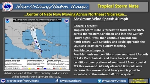
With the forecast track for newly-formed Tropical Storm Nate drifting closer toward New Orleans, city officials are warning residents to prepare for a threat of heavy wind and other possible effects of bad weather.
Read the full announcement from the mayor’s office below:
Today, Mayor Mitch Landrieu, along with City Officials, provided an update on Tropical Storm Nate. Today, Nate was upgraded to a tropical storm and has taken a significant westward shift, making probable landfall in Southeast Louisiana over the weekend. The chance for tropical storm-force winds has increased. Heavy wind is currently the primary concern for New Orleans through the weekend.
At this time, a Coastal Flood Advisory is in effect for New Orleans until noon on Sunday, Oct. 8. Coastal flooding is expected as tides are up to two ft. above normal tide levels. Potential storm surge flooding is probable through Saturday and Sunday. There is also potential for minor flooding of low-lying roadways outside of the flood protection system, near the Lakefront and in the Venetian Isles area.
As always during Hurricane Season, residents are reminded to make a plan and to have at least three days’ worth of supplies, including water, food, and medications on hand. To see tips on how to make a plan, visit https://ready.nola.gov/plan/hurricane/#prepare.
City Working with Local, State and Federal Partners on Preparations
Throughout this event, the City is working with local, federal and state partners such as Federal Emergency Management Agency (FEMA), Governor’s Office of Homeland Security and Emergency Preparedness (GOHSEP), Louisiana National Guard and the Army Corps of Engineers to understand the risks, vulnerabilities, and how the City can keep residents safe, which is our top priority.
Additionally, Mayor Landrieu led a tabletop briefing this morning with the National Weather Service and City officials on Tropical Storm Nate.
City Assets
The City currently has nearly 40 boats and over 20 high-water vehicles along with other rescue supplies staged at various fire and police stations, as well as four high-water vehicles and two boats stationed at Emergency Medical Services (EMS) headquarters.
Additionally, the New Orleans Police Department (NOPD) pre-staged 146 brand new barricades in flood-prone areas to prevent drivers from going into areas with high water. These barricades are designed for high visibility and auto traffic. Barricades and equipment are positioned and ready to be put in place at: Downman Road & Haynes Blvd., Gentilly Blvd. & Peoples Ave., Franklin Ave. & I-610 East and West, Gentilly Blvd. & Paris Ave. (Popeyes), Paris Ave. & Gentilly Blvd. (Parisite Skate Park), St. Bernard Ave & I-610 Exit, N. Broad St. & A.P. Turead Ave., Marconi Drive & Roosevelt Mall St., Canal Blvd. & Navarre Ave., Tulane Ave. & S. Carrollton Ave., Metairie Road & Pontchartrain Blvd., Gen. De Gaulle Drive & Hwy. 90, Gen. De Gaulle Drive & Woodland Drive, Press Drive & L. C. Simon Drive, and the I-10 Carrollton Off-Ramp.
Get Prepared
The City urges all New Orleans residents and businesses to stay prepared and informed as hurricane season continues. The City is committed to ensuring the safety of all residents, and the public is encouraged to help spread the word and make the entire community better prepared.
Develop a plan in advance to ensure that every family member knows what to do, who to call and where to go during an emergency. For more preparedness tips, visit https://ready.nola.gov/plan/hurricane/.
Out of an abundance of caution, the City’s emergency and operational departments are conducting preparation measures. Any changes in storm track and intensity could change the impacts for our area, so residents are advised to stay tuned to NOLA Ready and the National Weather Service for updates.
Sandbag Locations
Sandbags will be available at the following New Orleans Fire Department stations from 7 24 hours a day, starting Friday, Oct. 6:
- 987 Robert E. Lee Blvd.
- 2000 Martin Luther King Blvd.
- 4115 Woodland Ave.
- 2118 Elysian Fields Ave.
- 5403 Read Road
Update on Drainage System
The Sewerage and Water Board (S&WB) is working closely with New Orleans Office of Homeland Security and Emergency Preparedness and the Mayor’s office to monitor Tropical Storm Nate. S&WB and its contractors continue to work around the clock to repair all power and pumps to stabilize and strengthen the City’s drainage system. Since August, S&WB has repaired six drainage pumps and two turbines. Today, 108 of 120 drainage pumps are fully operational. Turbines 1, 3 and 6 are available for service with additional power being provided by 26 backup generators which were mobilized under emergency declaration. Additionally, S&WB is in the process of installing five Electro-Motive Diesel Generators at the Carrollton Water Plant and are scheduled to be available for service in the coming weeks.
Updates on pump availability can be found at www.swbno.org.