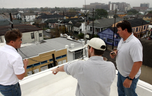
Freret resident Andy Brott, hydrologist W. Scott Lincoln and meteorologist Tim Erickson inspect a rain gauge on top of Brott’s house in mid January. (Robert Morris, UptownMessenger.com)
For many New Orleanians, Hurricane Isaac will be remembered for the long week without power and the maddening uncertainty as to when it would return.
But for a group of National Weather Service researchers, Isaac has proven interesting for what did not happen — street flooding — despite their discovery of what appears to have been a band of abnormally heavy rainfall right across Uptown New Orleans.
“Our biggest question is, ‘Where did the water go?'” said emergency-response meteorologist Tim Erickson during a recent trip to Freret Street to investigate.
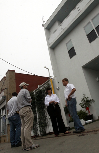
Most weather stations in the New Orleans area recorded 10 to 15 inches of rain during Isaac, but researchers have verified four gauges that recorded significantly higher amounts. One in Gretna recorded 23.96 inches; one at the U.S. Army Corps of Engineers office in Carrollton recorded 21.14 inches; another nearby at Audubon Park recorded 21 inches as well; and a station atop Andy Brott’s 43-foot tall home on Freret Street recorded 27.38 inches.
When the meteorologists climbed Brott’s roof to inspect his station earlier this month, they found a pole nearby that some rain might have slid down, increasing his total, they said. But that would likely only account for an inch or two of extra rainfall, they said, bringing it in line with the other three abnormally high readings.
In fact, when rain gauges fail during a hurricane, they most often under-perform, said National Weather Service hydrologist W. Scott Lincoln — because the rain blowing sideways is hard to catch.
“It’s atypical for gauges to over-report during hurricanes,” Lincoln said. “For four independent gauges all to fail in the same area, in the same way, the chance is very low.”
The meteorologists believe the anomaly is caused by a rain band off of Hurricane Isaac’s eyewall that parked over Uptown while the slow-moving storm stalled out. It is similar to seeing a downpour on one side of a street and sprinkle on the other, except that it lasted for hours, said Dr. Suzanne Van Cooten, hydrologist in charge of the Lower Mississippi River Forecast Center at the National Weather Service Slidell office.
“There are very distinct spatial patterns in this,” Van Cooten said. “It was a very intense thunderstorm complex rotating around the eyewall.”

The rain gauge on Andy Brott’s roof can be seen about 45 feet above street level, as Brott, Erickson, Lincoln and Suzanne Van Cooten talk below on the sidewalk. (Robert Morris, UptownMessenger.com)
The next step for the researchers is to compare their data with pumping records at the Sewerage and Water Board, they said, to determine how the water was moved. Very little street flooding was reported during Isaac around Uptown — an area normally notorious for it — and one explanation may lie in recent improvements to the drainage system, they said.
Ultimately, the information will allow National Weather Service forecasters to make better, more detailed predictions when the next storm comes around, said Van Cooten. Hurricanes bring a variety of threats — wind everywhere, but storm surge on the coast, and flooding inland — and by pairing recorded rainfall amounts with radar data, meteorologists will have more confidence in predicting extreme amounts — such as 20 inches or more — where the radar indicates it.
“We’re responsible for watches and warnings to protect lives and property,” Van Cooten said. “If we can start going back where these heavier rain bands set up and knowing we could potentially have a 20- to 24-inch rainfall, we will be better able to warn people what the maximum is that they can expect from that threat.”
The rainfall research project is primarily made possible by the proliferation of private weather stations in the New Orleans area — south of the Mississippi River, the meteorologists only have one data point in Belle Chasse to work with. As they refine their results, they are still looking for more data points — weather stations that don’t report results online, for example, or even less formal quantitative results, such as a bucket that someone might left outside before the storm and happened to measure the amount of rain in afterward. Pictures of street flooding against measurable objects are also helpful they said.
Anyone with data from Hurricane Isaac that might prove useful is encouraged to email hydrologist W. Scott Lincoln at scott.lincoln@noaa.gov.
All-
A big thanks to Scott Lincoln and NOAA for their hard work + if you have recoded data- please share.
If not here- at least with Scott, as it looks like our Cities
pumps and drainage actually worked.
But only data can prove that, so a link to ours is at-
http://www.wunderground.com/weatherstation/WXDailyHistory.asp?ID=KLANEWOR33&month=8&day=29&year=2012
At first glance, (and remembering/suffering May 8th 1995 floods-
http://en.wikipedia.org/wiki/May_8th_1995_Louisiana_flood ) I thought
there was little chance we had 2 feet rain in 24hrs. But look at those rain rates.
When paired with radar records and other WS totals- looks like Freret Uptown, Gretna, few others got slammed, while some got little.
Then there was all that horrible storm surge and river flooding in
Laplace, Belle Terre, Slidell, LJP-LPP-SBP-STP and +++…
Will be interested to see what NOAA finds-
My guess- Freretian water had little to no competition on its path to the Lake, and the new (temporary?) pumps and flood gates worked…?
But i’m no expert, and still know “each storm is different” + we all still food with more than “2inches in the first hour- followed by 1inch/hr after”- or on any day besides August 29th 2012-
7 years to the day post….
Best from http://www.brottwoks.com
Andy Brott